


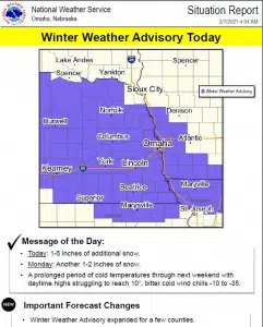
…WINTER WEATHER ADVISORY REMAINS IN EFFECT UNTIL 7 PM CST THIS EVENING…
Snow is expected today with total snow accumulations of 2 to 5 inches across portions of east central, northeast and southeast Nebraska and southwest and west central Iowa.
Plan on slippery road conditions. The cold wind chills as low as 15 below zero could cause frostbite on exposed skin in as little as 30 minutes.
Slow down and use caution while traveling. The latest road conditions for the state you are calling from can be obtained by calling 5 1 1.
Additional Comments from the National Weather Service:
Snow is expected over the region today, with amounts ranging from 1 to 5 inches. The heaviest totals are anticipated along and south Interstate 80. Roads will become slick and hazardous at times. .
Monday through Saturday Light snow is expected Monday morning, with additional accumulations of an inch or less. Very cold weather will continue through next week. Wind chills may become hazardous at times, especially Thursday through next weekend.
City of Lincoln Information:
Snow emergency parking bans: A snow emergency is in effect for the City of Lincoln. Parking is banned on both sides of emergency snow routes, bus and school routes and other major arterial streets. A map of these routes is available at snow.lincoln.ne.gov. Parking is banned on the odd-side of residential streets.
City operations: 80 crews continue to plow and treat arterial streets, school and bus routes. Extremely cold temperatures reduce the effectiveness of de-icing material, therefore more time is spent plowing to remove as much snow as possible off of priority routes. Residential plowing is scheduled to end Sunday afternoon. Use the Snow Fighting Map to follow plowing progress at snow.lincoln.ne.gov.


