


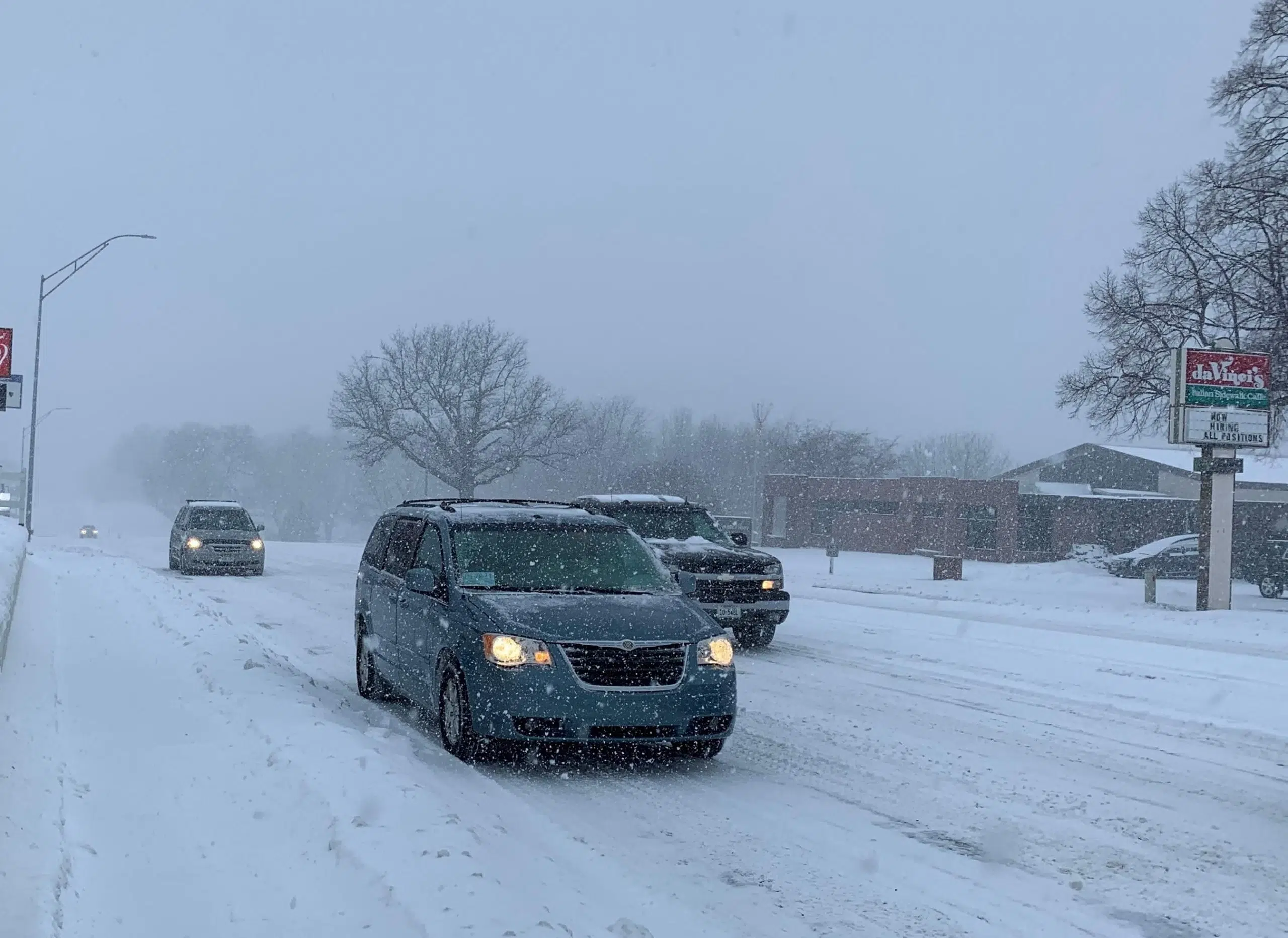
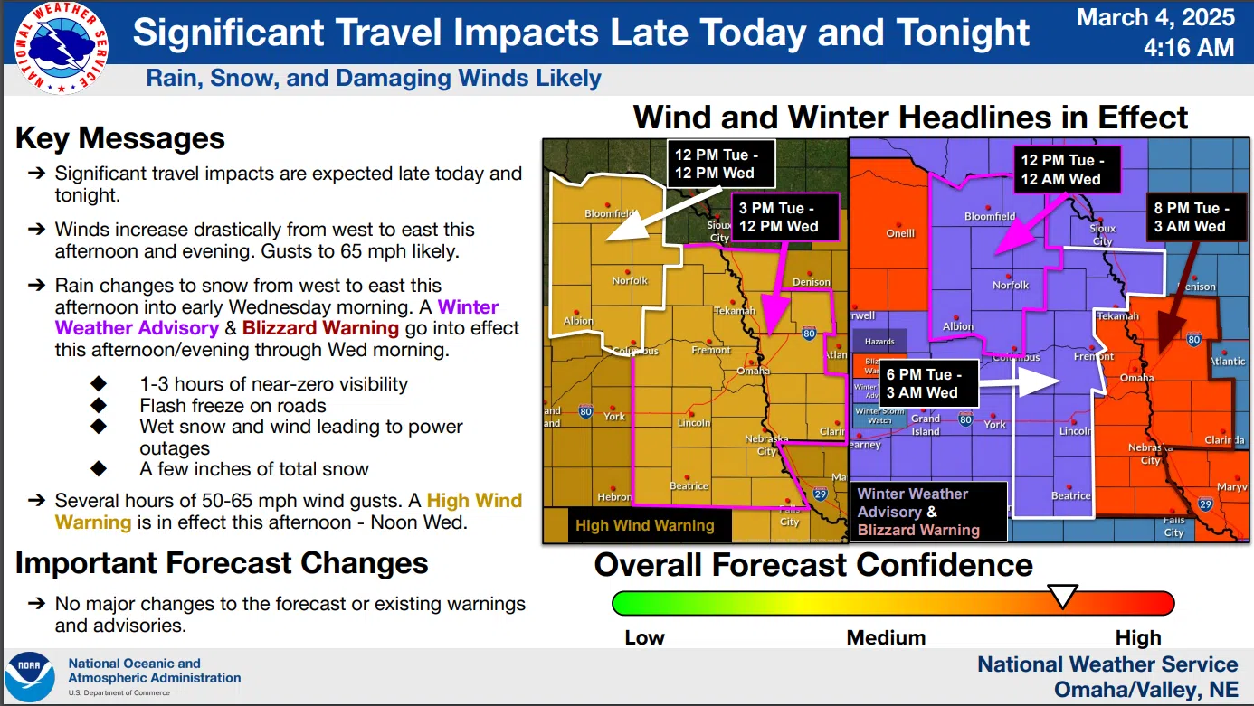
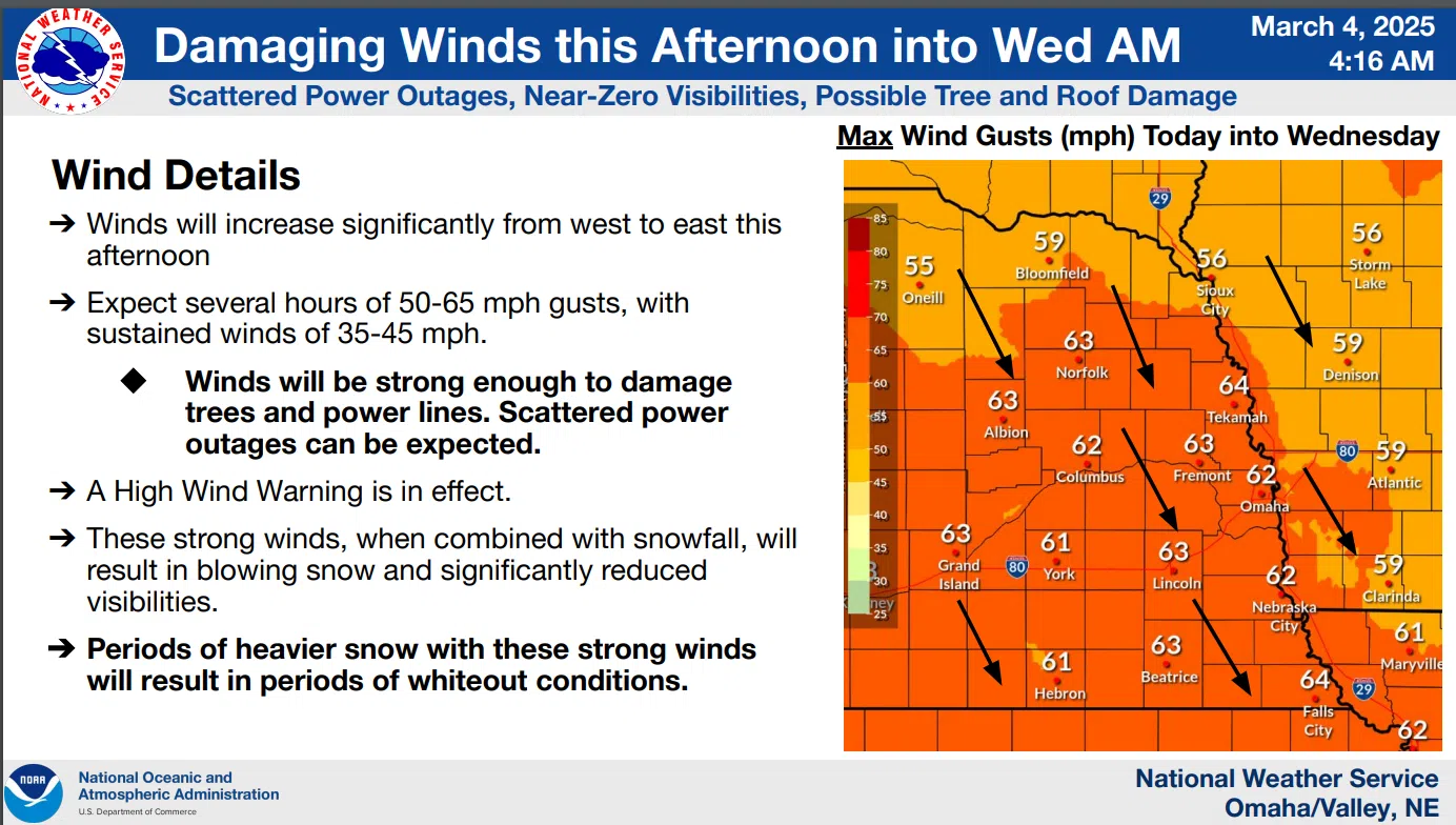
A potent storm is moving towards Eastern Nebraska with gusty winds the predominant feature forecast. Wind gusts overnight Tuesday into Wednesday could be near hurricane strength as the system moves out of the Southern Plains into the Midwest.
Snow accumulations in the Lincoln area are possible in the 2 to 4-inch range but conditions will be most hazardous with blowing and drifting snow and sharply reduced visibility. With rain changing to snow as the storm moves through there is also the possibility of flash-freezing on roads and sidewalks so extreme caution is advised.
Another band of accumulating snow may develop Thursday night into Friday with the best potential for accumulations north of I-80.
Tuesday morning’s extended National Weather Service Advisory is available here 3-4-25 NWS AM DssPacket
The latest National Weather Service details include:
…HIGH WIND WARNING IN EFFECT FROM 3 PM THIS AFTERNOON TO NOON CST WEDNESDAY…
…WINTER WEATHER ADVISORY IN EFFECT FROM 6 PM THIS EVENING TO 3 AM CST WEDNESDAY…
3-4-25 NWS
…HIGH WIND WARNING IN EFFECT FROM 3 PM THIS AFTERNOON TO NOON CST WEDNESDAY…
* WHAT…Northwest winds 35 to 45 mph with gusts up to 65 mph are expected.
* WHERE…Portions of southwest and west central Iowa and east central, northeast, and southeast Nebraska.
* IMPACTS…Damaging winds lasting several hours will blow down trees and power lines, and could cause minor roof damage.
Scattered power outages are expected. Travel will be difficult, especially for high-profile vehicles.
PRECAUTIONARY/PREPAREDNESS ACTIONS…
Remain in the lower levels of your home during the windstorm, and avoid windows. Watch for falling debris and tree limbs. Use caution if you must drive.
***
…WINTER WEATHER ADVISORY IN EFFECT FROM 6 PM THIS EVENING TO 3 AM CST WEDNESDAY…
* WHAT…Snow expected. Total snow accumulations between 1 and 3 inches. Winds gusting as high as 65 mph. Flash freezing is expected.
* WHERE…Portions of west central Iowa and east central, northeast, and southeast Nebraska.
* IMPACTS…Roads will become slick and hazardous, impacting the end of the evening commute. Periods of whiteout conditions area possible. Very strong winds could cause tree damage and power outages.
PRECAUTIONARY/PREPAREDNESS ACTIONS…
Slow down and use caution while traveling. The latest road conditions for the state you are calling from can be obtained by calling 5 1 1.
Be prepared for slippery roads. Slow down and use caution while driving.
If you are going outside, watch your first few steps taken on stairs, sidewalks, and driveways. These surfaces could be icy and slippery, increasing your risk of a fall and injury.
3-4-25 NWS