


State officials are preparing for a historic spring storm that will impact Nebraska starting Friday.
Bryan Tuma with the Nebraska Emergency Management Agency and says they have been carefully monitoring the situation with the National Weather Service in Cheyenne, Wyoming, North Platte, Hastings and Omaha Their Emergency Watch Center will continue to monitor the situation as it unfolds over the weekend. They are working with other state agencies and officials to evaluate how this will impact travelers during the storm event.
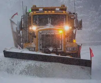
Eight to 10 inches of snowfall is expected in the Panhandle. As the storm moves east, snow will transition to rain with 2 to 4 inches possible over the next two to three days. Freezing rain and drizzle is possible in some areas of the state. The Panhandle area can expect the snow to start falling Friday night but forecast models continually change.
Tuma says this is bringing back thoughts of the March 2019 Bomb Cyclone that caused massive flooding in eastern Nebraska. Tuma says weather conditions were much different in that event. Tuma says, “There are key considerations to take into account. Soil moisture and temperatures are much different this year than in 2019. Much of the state experienced drying trends over the past summer and through the fall and there is more capacity for moisture to be absorbed than runoff taking place. Our ground temperature has risen over the past few weeks resulting in higher soil temps. That is allowing for greater absorption. Snow pack from this winter is essentially gone and that snow melt has been channeled through our streams and rivers. River levels are also much lower this year compared to 2019. Most of the ice jams have been mitigated over the last few weeks and this will allow the run-off to work its way through the system.”
Moe Jamshidi is the acting director of the Nebraska Department of Transportation and says they will provide up to date road conditions on Nebraska 511. Travelers are urged to download the app.
Nebraska State Patrol Colonel John Bolduc says, “Anytime meteorologists and the National Weather Service use terms like “historic”, It is critical the public knows as much as possible ahead of time.” Trooper schedules have been adjusted so they can respond to any stranded motorist in western Nebraska. Travel will be impacted in the Panhandle, Colorado and Wyoming. He says travel should be avoided. Those needing to be out should have a winter travel kit prepared and make sure your cell phones are charged to contact emergency providers. Bolduc again stresses that travel is not recommended.
Central & Eastern Nebraska
With the combination of rain, flooding and flash flooding are a possibility. NDOT urges all drivers to never drive over a flooded roadway. Any water over the road could stall or even float a vehicle. Should you encounter a flooded roadway, please remember to turn around – don’t drown.
“This latest storm looks to have significant impact in Nebraska’s Panhandle in addition to our neighbors in Wyoming and Colorado,” said acting NDOT Director Moe Jamshidi. “Our crews will be out working to clear roadways as conditions allow in a potential blizzard. With the forecasted snow fall totals coupled with high winds, we urge against all unnecessary travel in the blizzard affected areas. If you must travel during this winter storm, know before you go by checking 511.nebraska.gov for road conditions and closures and always travel well established routes. Should motorists encounter flooding, remember to never travel over a flooded roadway.”
“Our troopers will be prepared to help any motorists who need assistance,” said Colonel John Bolduc Superintendent of the Nebraska State Patrol. “We urge all drivers to be vigilant and avoid travel if conditions aren’t favorable.”